Showing posts with label drought. Show all posts

Wednesday, 4 February 2015

Plant hormone signals and climate models, plus a mathematical surprise

A new study examining the links between soil moisture and leaf stomata should be of interest to both plant physiologists and climate modellers. It was published in the journal Ecological Modelling (27 January 2015, Ecological Modelling 300 (2015) 81–88), and is open access, so freely accessible. Below the lead author, Dr Chris Huntingford of the Centre for Ecology & Hydrology (CEH), explains what they did and how the analysis reveals an unexpected mathematical twist:

“A small team of us have just published a paper on assessing how the equations link together that describe ABA (abscisic acid) messaging in plant systems. Possibly more than most pieces of mathematical analysis, our study turned into a bit of an adventure, including an unexpected outcome.

ABA is a hormone which passes through vegetation, and provides a signal to leaf stomata regarding the amount of soil moisture available. Stomata control both evaporation and photosynthesis and, if soil moisture is depleted, then generally plants close such pores as a protection mechanism during periods of drought.

Climate models are designed to estimate adjustments in near-surface temperature and humidity (amongst many other quantities) in response to raised atmospheric greenhouse gas concentrations. However the land surface is a fully coupled part of the climate system, not simply responding to any imposed adjustment to weather conditions, but also affecting them. This can be through multiple feedbacks, one of which is how rain water is returned to the atmosphere via evaporation. In addition, any better understanding of transpiration losses by vegetation can aid impacts planning of viable crops for future perturbations to the climate system.

Despite this need, many land surface descriptions within climate models contain only an empirical semi-linear response to soil stress. This varies from no effect at a critical moisture level, down to complete shut-down at a prescribed soil moisture wilting point.

Detailed laboratory and field measurements of ABA concentration at the leaf level reveal a strong dependence on both soil moisture and the actual transpiration rate. Concentration levels then influence the amount to which stomata open. This allows the opportunity of building more accurate, chemically-based descriptions into the functioning of the terrestrial part of climate models, with performance verifiable against ecological data. Hence the first role of the paper is to describe the equations in full, and in that context.

Figure 2 of the paper, providing a schematic of the main equations analysed
At the same time, where climate models frequently do excel is in non-water stressed representation of photosynthetic response, including the impact of temperature and light effects. But these descriptions are not included in models of ABA control on stomata, giving the opportunity to merge both. We are not the first to suggest this (see earlier paper, Dewar, 2002) but here, as we unite equation sets, we fully analyse their projections of such a common model to soil moisture, light, temperature, CO2 concentration and surface humidity – our Figure 1 within the paper. This can be important to check as such linking can create odd cross-effects between model components. Fortunately we find this more ABA-based combined model does reproduce the salient features of expected stomata response across a range of imposed environmental conditions. We offer this as a possible future candidate for inclusion in climate models.

There is, however, also a mathematical surprise!

Despite our linking together in a common framework, which generally makes models more complex, we find that equation re-arrangement may actually simplify things. Stomatal response can be re-written as a function of soil moisture, evaporative flux, atmospheric CO2 concentration and photosynthetic flux only. We are not suggesting that this is necessarily what the stomata “see” to guide their responses (eg with drivers such as temperature occurring instead of via influence on photosynthesis). But the ability to write the equations in this form links to a long-term “store” of the hydrological cycle, ie soil moisture, and to a more instantaneous flux, ie transpiration, the latter fluctuating more with weather conditions.  And, in a symmetry for the carbon cycle, links to the “store” of atmospheric CO2 concentration, and again to more immediate fluctuations of photosynthetic uptake.

Could plants therefore respond to the more slowly changing stores in the carbon and water cycles, but using fluxes to provide time-evolving corrections dependent on the precise passing meteorological conditions?

Although our priority is to try and contribute towards improving process representation in land surface models, we really hope that other authors might investigate further the “stores-fluxes” concept that the equations of this model hint at.”

Dr Chris Huntingford

Additional links


Chris Huntingford, D Mark Smith, William J Davies, Richard Falk, Stephen Sitch, Lina M Mercado. Combining the [ABA] and net photosynthesis-based model equations of stomatal conductance. 2015. Ecological Modelling. doi: 10.1016/j.ecolmodel.2015.01.005

The full paper is open access and can be read by anyone. The work was carried out by scientists from CEH, Exeter University, Lancaster University and the IUCN.

Staff page of Dr Chris Huntingford


Wednesday, 3 September 2014

CEH at the British Hydrological Society National Symposium

Several CEH scientists are in Birmingham this week at the 12th British Hydrological Society National Symposium. This year’s theme is “Challenging hydrological theory and practice.”

The symposium, which takes place from 2-4 September 2014, is one of the main meetings for the UK’s hydrological community, a community in which CEH plays a key role, through both our research on issues such as water resources, floods and droughts, and our extensive hydrological data management remit.

CEH has a stand at the conference. Visitors are being shown this video highlighting the wide range of hydrological research we carry out:


Ten CEH staff are speaking at the conference on a wide range of subjects. Their presentations are as follows:

1. Natural or designer environmental flows for a changing world? Prof Mike Acreman

2. Predicting physical habitat sensitivity to abstraction. Cedric Laizé

3. Overdispersion in peak over threshold (POT) flow data and its effect on flood frequency practice.
Dr Ilaria Prosdocimi

4. The new FEH rainfall depth-duration-frequency model: results,
comparisons and implications. Lisa Stewart

5. What do we talk about when we talk about drought? Jamie Hannaford

6. Real-time modelling of surface water flooding hazard and impact at
countrywide scales. Dr Steven Cole

7. Presentation of the new CEH-GEAR dataset: fine resolution daily and monthly
areal rainfall estimates for the UK for hydrological use Dr Maliko Tanguy

8. Can land use and land management make a difference to water
availability? Helen Houghton-Carr

9. How do we want to access hydrological data over the web? Matt Fry

10. Ensuring UK hydrometric data is fit-for-purpose through a national
Service Level Agreement. Katie Muchan

Conference attendees are tweeting using the hashtag #BHS2014

Links

Conference website

Conference programme

Monday, 10 March 2014

Natural Hazards Science Area

CEH's new Science Strategy identifies three interdependent, major societal and environmental challenges: Securing the Value of Nature, Building Resilience to Environmental Hazards, and Managing Environmental Change. We're delivering our strategy by Science Areas and underpinning activities, and over the next few weeks we are profiling these on our blog.

In this post we focus on our Natural Hazards Science Area, which includes some of our work on floods and droughts. Natural hazards also include threats from parasites, pathogens and invasive species, and threats from natural air pollution incidents.


Natural hazards are of increasing concern for humanity because of population growth and increased societal vulnerability due to trends in urbanisation and land-use change. They have been identified by the National Security Review as some of the most significant risks to the UK in terms of economic, social and environmental consequences.

A key demand is to improve our prediction and estimation of natural hazards and develop knowledge to better manage and minimise their impacts on our society, economy and environment.


Hydro-meteorological science is an important element of our research. Within CEH we have teams of scientists working on furthering our understanding of hydrological processes, water resources, water information management, hydrological status and reporting, the climate system, hydrological modelling and risk, and hydrological modelling and forecasting. Our science and data played a key role in informing UK operational agencies during the recent flooding events.


Our future research objectives include the development of physical and statistical models to better quantify the current and future risks from extreme rainfall and floods at multiple temporal and spatial scales. We are also developing web-based tools for seasonal forecasting of river flows to support flood and drought management in the UK and overseas.

What is a drought? - read more on the CEH website

CEH also has an important research role in helping to develop solutions to tackle problems caused by biological invasions.


We are working on methods to supply predictions of their arrival and spread, underpinned by rigorous risk assessment. We will deliver new systems to predict the arrival of invasive non-native species with particular focus on their pathways of arrival, spread and associated disease pathogens.


Find out more about our Natural Hazards Science Area, including a Science Area Summary [PDF], on the CEH website.

Additional information


CEH Science Strategy 2014-2019

Staff page of Nick Reynard, Natural Hazards Science Area Lead


Tuesday, 22 October 2013

National hydrometric data - what does the future bring for the UK's NRFA?

In two previous blog posts this month, we explored how the hydrometric data held by the National River Flow Archive and the National Groundwater Level Archive have been used in past and present scientific research, and how such a valuable data resource is vital for taking a long view of both hydrological trends and significant one-off events. Our series has coincided with a special meeting, on Tuesday 22 October 2013, to celebrate 30 years of the NRFA being hosted at CEH's Wallingford site. To conclude the series, Jamie Hannaford, head of the National River Flow Archive, looks to the future and at what the next few years might bring...

The past 30 years have seen incredible change in how we do our jobs, most obviously in the technology used to gather and disseminate hydrometric data. The next 30 years will undoubtedly see huge change again. When you think about it, 30 years is a generational timescale, it's a career span, it's a period that can expect to see life-changing developments. Hydrometric data and analysis is already important to society for underpinning effective water management, but it will assume even greater importance in global water management over the next 30 years, thanks to the challenges of population growth and movement, land use change and of climate change leading to an intensification of the hydrological cycle.

The NRFA, as the UK's national hydrometric information service, will be crucial to meeting these challenges, lying as it does at the heart of the hydrometric information lifecycle and managing as it does a long-term archive that will be able to take an ever longer view of events such as the 2010-2012 drought to flood transformation. Reliable, easily accessible, contextualised data and analysis will play a key role as scientists and water practitioners meet the world's water resource management needs.

The NRFA already provides its data and analysis in many formats


From the original print publications the NRFA delivered in the 1980s, to the digital outputs it now provides, our data is already, and will continue to be, served in many formats, but our fundamental maxim will always be to turn the data into valuable information. We always make sure we know where the data is coming from, so we can guide our end users.

The technological landscape will certainly continue to develop. Will we be a nation of armchair hydrologists by 2043? In some respects, thanks to remote sensing and satellite capabilities, it's possible to some extent now. But as well as opportunities, technology brings its own challenges - both in the huge amount of data that can be gathered and in the interpretation and validation of that data. For all the hydrometric data that can be gathered, we still need to understand what it is telling us. And we still need our monitoring partners to collect data first-hand to complement the models and the satellite technology.

The provision of reliable hydrometric data in the 21st century will be
crucial for global water management

Future developments

An important area for the NRFA now is to look at how to integrate our river flow data with other types of monitoring, for example near real-time soil moisture data, citizen science initiatives etc, to build up a fuller environmental picture. Our role will be to bring these other types of information together with the river flows; to help with interpreting and understanding them in context with other environmental variables.

Currently we are reviewing our hydrological summaries and looking at different options for enhancement, for example using the best modelling capabilities from CEH and other organisations to deliver improved outlooks and better drought indicators. We are working more closely than ever with international colleagues in organisations such as the US National Drought Mitigation Center and CSIRO in Australia, and aim to improve the information that we and other national hydrometric data providers can supply. It is a challenging task to undertake when hydrometric networks are under pressure worldwide, along with the resources for long-term monitoring.

In the shorter term, you can expect the NRFA to offer daily catchment rainfall on its website from next year. We will also be taking on the validation for HiFlows-UK, the UK's principal source of flood peak data, and making this available from our website in the near future.

Who can really say what the NRFA in 2043 will look like? The last 30 years have been a tremendous effort of stewardship, and the next 30 years will be also, but we are ready and able for the challenge, thanks to the support of our partners. Our data and analysis has informed the likes of the Pitt Review on flooding, which followed the 2007 summer floods, as well as the National Ecosystem Assessment and the IPCC's recent 2013 climate change assessment. We will continue to give that much needed national, strategic assessment that is crucial for water management in this country.

Jamie Hannaford

Additional reading


Dixon, H, Hannaford, J and Fry, M J, 2013, The effective management of national hydrometric data: experiences from the United Kingdom. Hydrological Sciences Journal.

The 2010-2012 drought and subsequent extensive flooding - a remarkable hydrological transformation by Terry Marsh, Simon Parry, Mike Kendon & Jamie Hannaford. 2013. PDF [7.05mb]

Hydrometric data - the long view (first in our special blog series on the NRFA and hydrometric data)

An unprecedented hydrological transformation (second in our blog series)

View photos from the NRFA 30th anniversary event on Flickr

Related links


National River Flow Archive

Staff page of Jamie Hannaford, CEH

Thursday, 10 October 2013

An unprecedented hydrological transformation

A huge number of scientific papers have delved into the extraordinary data held by the National River Flow Archive and National Groundwater Level Archive. As our blog series on hydrometric data continues, Simon Parry of CEH (right) discusses one of the most recent papers to use the data, newly published in the Weather journal, which analyses the dramatic transformation from drought to flood in the UK during the summer of 2012.

Whilst this year's fine and dry summer was very much welcome, it was not typical of the more unsettled summers of the last few years. Although the Olympic and Paralympic Games in 2012 were spared the worst of the weather, from April 2012 onwards a succession of wet fronts drenched the UK, in particular England & Wales, resulting in the wettest year for more than a century.

This episode emphatically put to an end concerns about the water resources situation, which saw hosepipe bans implemented in April across south, central and eastern England affecting 20 million consumers. Recent research by CEH scientists, in collaboration with the UK Met Office, published last month in Weather, finds that the transformation from drought to floods in England & Wales is without modern parallel in the historical record (Parry et al. 2013).

The extreme drought of 1975-76 remains the most severe in the historical record, most likely the worst experienced in the UK for at least the last 250 years (Rodda & Marsh 2011). This episode was terminated dramatically in September and October 1976, over which time England & Wales received almost double the long-term average rainfall.

The 2010-12 drought did not reach the same intensity as 1975-76 (Kendon et al. 2013); the summers were not hot or particularly dry in 2010-12, in contrast with heatwave-dominated droughts in 1976 and 2003. However, the rainfall shortages were concentrated in the winter half-years (October-March), a vital time for the recovery of water resources and, as such, outflows from England & Wales in March 2012 were lower than the corresponding point in 1976. Hosepipe bans were implemented in several areas at the end of the normal groundwater recharge season (April); there was little prospect of improvement in the water resources situation, barring something extraordinary happening...

Something extraordinary did happen. Whilst the transformation in 2012 may not have been as spectacular in rainfall terms as that of 1976, England & Wales recorded new record rainfall (series from 1766; Alexander & Jones 2001) for April, June and the summer half-year (April-September), and April-December 2012 was the wettest of any nine-month period in ~250 years.

Flood damage in England, December 2012. Photo: Heather Lowther


Groundwater recharge through the summer half-year

The most important impact of the succession of rain-bearing frontal systems was to re-wet soils which allowed the replenishment of groundwater to resume. What made the transformation in 2012 particularly unprecedented was the resumption of groundwater recharge through the summer half-year; the patterns of hydrological response tracked in the opposite direction to normal seasonal conditions.

Perhaps owing to the British preoccupation with the weather, much attention is given to rainfall figures in characterising the water situation in this country. However, water resources are more complex than this; the relationship between rainfall and runoff is not one-to-one, owing to catchment characteristics and antecedent conditions.

The distinction between a transformation in rainfall and the unprecedented hydrological transformation is an important one; the former would not necessarily have terminated hydrological drought conditions, but the latter did so emphatically. If there had been no concurrent response in groundwater levels following the rainfall, it is likely that hosepipe bans would have remained in place even through a moderately wet summer. This would have been a difficult message for the water companies to communicate to the public, so perhaps the industry was happy on more than one level to have witnessed a hydrological transformation without modern parallel.

Simon Parry

Simon Parry is a hydrologist based at the Centre for Ecology & Hydrology's Wallingford site.


References


Alexander, L V, and Jones, P D (2001) Updated precipitation series for the UK and discussion of recent extremes. Atmospheric Science Letters, 1, 142-150.

Kendon, M, Marsh, T and Parry, S (2013) The 2010-2012 drought in England and Wales. Weather, 68 (4), 88-95.

Parry, S, Marsh, T and Kendon, M (2013) 2012: from drought to floods in England and Wales. Weather, 68 (10), 268-274.

Rodda, J C and Marsh, T J (2011) The 1975-76 drought - a contemporary and retrospective review, Centre for Ecology & Hydrology. 58pp. [PDF, 13mb]

Additional information


A comprehensive report by Terry Marsh, Simon Parry and Jamie Hannaford, in collaboration with Mike Kendon (Met Office), on the 2010-12 drought and subsequent hydrological transformation will be published later this month and will be available to download freely from the CEH website.

Next in our hydrometric data blog series, Looking forward - where the archives are going next... Watch this space!

Related links

CEH Blog: Hydrometric data - the long view

National River Flow Archive  

Thursday, 3 October 2013

Hydrometric data: The Long View

Each week BBC Radio 4's The Long View uses a variety of expert witnesses to examine stories from history that resonate in today's headlines.

Later this month, CEH will host more than 100 distinguished hydrologists who will spend a day taking the 'long view' of the data collection and research work of the UK's National River Flow Archive (NRFA) and National Groundwater Level Archive (NGLA), both of which have been hosted at our Wallingford site since the early 1980s, but which contain records dating back to the first half of the 19th century.

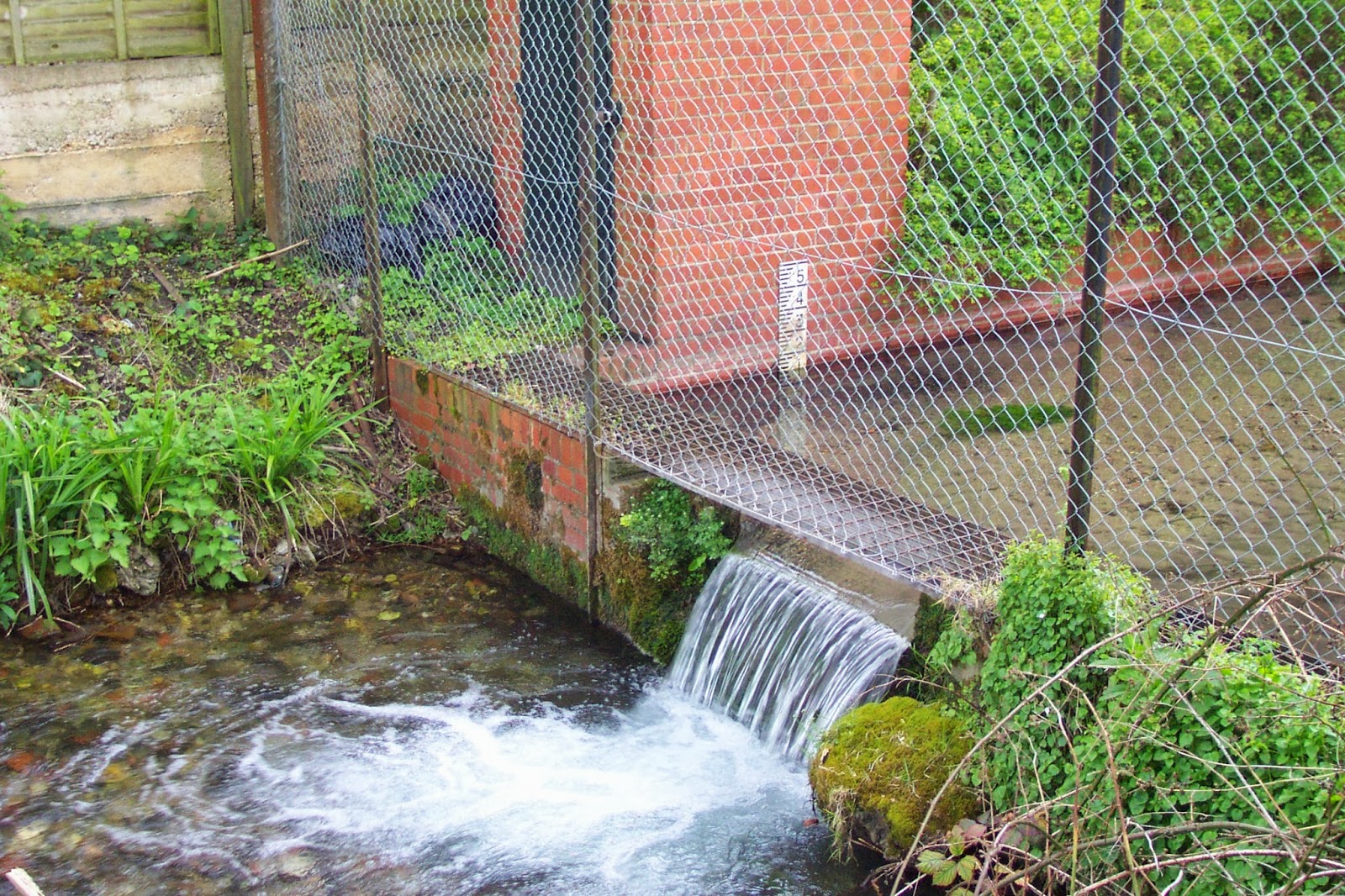
Wendover Springs - thought to be the earliest extant stream flow monitoring
site in the UK. 


The 30th anniversary celebration of the Wallingford move, to be held on 22 October 2013, will review the achievements of the archives and the exploitation of this rich hydrological data resource by a broad user community, which includes regulators such as the Environment Agency, water companies, academic scientists, and environmental and engineering consultancies. The data has also made its way into several scientific papers referred to in the recent IPCC WG1 assessment.

In addition to river flow and groundwater level data, rainfall records and reservoir levels are also held in the archives and the incredible dataset has allowed CEH and BGS scientists to produce a variety of key publications examining both hydrological trends – for example, Are UK floods getting larger? – and the significance of one-off events, such as the 1976 drought. Comparisons between the latest data and the historic record also provide the backbone of the UK's monthly hydrological summary.

Whilst delving through the archives in preparation for this post, I came across this fascinating history of hydrological monitoring before 1985 [PDF], which details how, although Britain has a three centuries-long history of rainfall recording, river flow monitoring only became 'fashionable' after the second world war as industry and government increased their demand for water. The work to establish a national river flow gauging network in the 1950s and 1960s built on a small number of sites that had been established over the previous century, including Wendover Springs in Buckinghamshire - thought to be the earliest extant stream flow monitoring site in the UK.

On the day itself, presenters will look back at how hydrometric monitoring developed in the UK, in response to factors such as the perceived increase in water requirements. They will also examine some of the latest techniques for both monitoring the UK's water cycle, investigate how monitoring and the archive might develop in the future, and tackle the difficult question of what data should we be archiving nationally, given the resource constraints imposed by the current financial situation. In summary, they will take a 'Long View' of a data archive from one of the UK's major environmental monitoring networks, an archive which is particularly important because the UK climate is inherently variable, so short-term tendencies may well not be indicative of long-term trends.

Barnaby Smith

CEH website: Images of gauging stations which have provided some of the oldest records in the archive

Flickr: Album of historic images from the Pynlimon catchments

Additional information


Over the next couple of weeks we will be blogging in more detail about some of the material being presented at the meeting. Further details of the meeting can be found here. Registration is now closed but we will be making much of the content available from this blog and the NRFA pages on the CEH website.

If you're interested in learning more, take a look at the NRFA web pages, where you can find reams of information on how monitoring takes place and how the data is used, and you can also download data for more than 400 of the UK's river flow gauging sites. Information about the records and details of scientific papers which have used the records can be found on the NRFA publications pages.

Friday, 28 June 2013

CEH contributes to new BES report on impact of extreme weather events on freshwater ecosystems

Dr Linda May and Dr Francois Edwards recently led the CEH input to a British Ecological Society Centenary report on the impact of extreme weather events on freshwater ecosystems. The report was launched at a special reception on Tuesday 25 June 2013 at Westminster.

Lake and river ecologists from across the Centre for Ecology & Hydrology were involved in contributing to the report, which aims to provide more information on the problems that floods, droughts, heatwaves etc present for freshwater systems, affecting water quality and quantity.

The launch event was attended by more than 100 people and included speeches from Andrew Miller MP, BES President Professor Georgina Mace and Huw Irranca-Davies MP, who officially relaunched the BES Ecological Issues series, which the new report has been published within.

Earlier in the day Dr Edwards helped run a workshop based on the report at the "Future Water 2013 Building resilience:  A sector fit for the future" meeting at the Royal Geographical Society.

To accompany the full report, a short 2-page summary and policy brief was also published.

Read the full report: The Impact of Extreme Events on Freshwater Ecosystems (7.40mb, PDF from the BES website)

More about the launch event can be read on the British Ecological Society blog.

Executive summary and policy brief

Additional information


RGS meeting agenda

Staff page of Dr Francois Edwards, CEH

Thursday, 16 February 2012

Dealing with 'drought' questions

'Drought' questions have been flooding(!) in to CEH this week as several organisations release new data on the UK water situation. Several papers have been having a field day with their headlines. Our favourite was '2011 was the driest year in England and Wales for 90 years' (actually the rainfall records indicate that 2010 was drier than 2011).

Whilst we've been speaking to many journalists on the phone it also seems appropriate to post a selection of useful links giving background on the current situation, and some of the context behind the headlines.

First here is our standard answer to 'What is a drought?' - the simple answer being "droughts mean different things to different people"

Second we run the National Hydrological Monitoring Programme* (more details below). This recent blog post gives more background on what we do with hydrological data (which is rather different to the roles played by other organisations such as the Environment Agency and the Met Office).

We have also just published our latest monthly hydrological summary for the UK, covering the month of January 2012.

The introduction to the summary starts:
“The synoptic patterns which have produced a remarkably sustained exaggeration in the NW-SE rainfall gradient across the UK continued in January. Much of central, eastern and southern England was again relatively dry and the development of the current regional drought now extends across three winter periods with a range of impacts embracing water resources, agriculture and the aquatic environment.” ...and continues... “In the absence of an unusually wet late winter and early spring (as happened in 2000 for example), it is now virtually inevitable that a significant degree of drought stress will be experienced (in some parts of England) in 2012. The magnitude of that stress, and its spatial extent, will be heavily influenced by rainfall over the next 8-10 weeks.”

Key information from the summary can be read here.

A pdf copy of the full 12-page summary can be downloaded from this link.

If you wish to reproduce figures from the summary please respect the copyright credits contained within the document.

And finally please call us if you have queries. We'll try and help!

Update - 18:30 16 February 2012

A number of news outlets are reporting that "This week the Centre for Hydrology and Ecology reported that average rainfall so far this winter was the lowest since 1972." We're not aware that any of our staff have stated this to journalists and believe it may be a misinterpretation of the following paragraph in the January Hydrological Summary (rainfall section, page 1).

"Accumulated rainfall deficiencies, although locally variable, are exceptional across a wide range of durations. Provisionally, the Anglian region recorded its lowest March-January rainfall in a series from 1910 (over the same 11-month period Scotland established a new maximum precipitation total). As notably, some parts of the Midlands have reported only three months with above average rainfall since November 2009 and the accumulation for the subsequent 26 months is the lowest on record (for periods beginning in December) in a series from 1910; for the Thames basin it was the driest since 1972-74 – such deficiencies were more common in the 19th century."

The National Hydrological Monitoring Programme

*The Centre for Ecology & Hydrology jointly operates the National Hydrological Monitoring Programme (for the UK) in conjunction with the British Geological Survey. NHMP scientists produce the UK Monthly Hydrological Summary which assesses rainfall, river flows, groundwater and reservoir levels. They also operate the UK’s National River Flow archive. The NHMP also has a remit to analyse major flood and drought events in the UK and analyse long term trends in UK hydrological data. http://www.ceh.ac.uk/data/nrfa/nhmp/nhmp.html

Posted by Barnaby Smith