Showing posts with label weather. Show all posts

Friday, 25 July 2014

Royal Meteorological Society members visit CEH

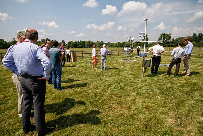
Members of the Royal Meteorological Society's Meteorological Observing Systems Special Interest Group have paid a visit to CEH to learn more about aspects of our monitoring work. The visitors were given a tour of our Meteorological Station at Wallingford (thankfully the weather was warm and sunny at the time!) and also heard more details about its history and observations from site manager Katie Muchan:


The visitors also heard a presentation from Dr Gareth Old about CEH's River Lambourn Observatory and research into chalk river systems:


Dr Jonathan Evans of CEH also presented on progress and early results from COSMOS-UK, the UK soil moisture monitoring network. The network will deliver real-time weather monitoring and field scale measurements of soil moisture across the United Kingdom.

Members of the RMetS Special Interest Group on Meteorological Observing Systems visit
CEH's Wallingford Meteorological Station, July 2014. Photo: Paul Fisher/ CEH


Further reading


Winter 2013/2014 rainfall records at CEH's Wallingford meteorological station 

A window on weather conditions at Wallingford

Tuesday, 22 October 2013

National hydrometric data - what does the future bring for the UK's NRFA?

In two previous blog posts this month, we explored how the hydrometric data held by the National River Flow Archive and the National Groundwater Level Archive have been used in past and present scientific research, and how such a valuable data resource is vital for taking a long view of both hydrological trends and significant one-off events. Our series has coincided with a special meeting, on Tuesday 22 October 2013, to celebrate 30 years of the NRFA being hosted at CEH's Wallingford site. To conclude the series, Jamie Hannaford, head of the National River Flow Archive, looks to the future and at what the next few years might bring...

The past 30 years have seen incredible change in how we do our jobs, most obviously in the technology used to gather and disseminate hydrometric data. The next 30 years will undoubtedly see huge change again. When you think about it, 30 years is a generational timescale, it's a career span, it's a period that can expect to see life-changing developments. Hydrometric data and analysis is already important to society for underpinning effective water management, but it will assume even greater importance in global water management over the next 30 years, thanks to the challenges of population growth and movement, land use change and of climate change leading to an intensification of the hydrological cycle.

The NRFA, as the UK's national hydrometric information service, will be crucial to meeting these challenges, lying as it does at the heart of the hydrometric information lifecycle and managing as it does a long-term archive that will be able to take an ever longer view of events such as the 2010-2012 drought to flood transformation. Reliable, easily accessible, contextualised data and analysis will play a key role as scientists and water practitioners meet the world's water resource management needs.

The NRFA already provides its data and analysis in many formats


From the original print publications the NRFA delivered in the 1980s, to the digital outputs it now provides, our data is already, and will continue to be, served in many formats, but our fundamental maxim will always be to turn the data into valuable information. We always make sure we know where the data is coming from, so we can guide our end users.

The technological landscape will certainly continue to develop. Will we be a nation of armchair hydrologists by 2043? In some respects, thanks to remote sensing and satellite capabilities, it's possible to some extent now. But as well as opportunities, technology brings its own challenges - both in the huge amount of data that can be gathered and in the interpretation and validation of that data. For all the hydrometric data that can be gathered, we still need to understand what it is telling us. And we still need our monitoring partners to collect data first-hand to complement the models and the satellite technology.

The provision of reliable hydrometric data in the 21st century will be
crucial for global water management

Future developments

An important area for the NRFA now is to look at how to integrate our river flow data with other types of monitoring, for example near real-time soil moisture data, citizen science initiatives etc, to build up a fuller environmental picture. Our role will be to bring these other types of information together with the river flows; to help with interpreting and understanding them in context with other environmental variables.

Currently we are reviewing our hydrological summaries and looking at different options for enhancement, for example using the best modelling capabilities from CEH and other organisations to deliver improved outlooks and better drought indicators. We are working more closely than ever with international colleagues in organisations such as the US National Drought Mitigation Center and CSIRO in Australia, and aim to improve the information that we and other national hydrometric data providers can supply. It is a challenging task to undertake when hydrometric networks are under pressure worldwide, along with the resources for long-term monitoring.

In the shorter term, you can expect the NRFA to offer daily catchment rainfall on its website from next year. We will also be taking on the validation for HiFlows-UK, the UK's principal source of flood peak data, and making this available from our website in the near future.

Who can really say what the NRFA in 2043 will look like? The last 30 years have been a tremendous effort of stewardship, and the next 30 years will be also, but we are ready and able for the challenge, thanks to the support of our partners. Our data and analysis has informed the likes of the Pitt Review on flooding, which followed the 2007 summer floods, as well as the National Ecosystem Assessment and the IPCC's recent 2013 climate change assessment. We will continue to give that much needed national, strategic assessment that is crucial for water management in this country.

Jamie Hannaford

Additional reading


Dixon, H, Hannaford, J and Fry, M J, 2013, The effective management of national hydrometric data: experiences from the United Kingdom. Hydrological Sciences Journal.

The 2010-2012 drought and subsequent extensive flooding - a remarkable hydrological transformation by Terry Marsh, Simon Parry, Mike Kendon & Jamie Hannaford. 2013. PDF [7.05mb]

Hydrometric data - the long view (first in our special blog series on the NRFA and hydrometric data)

An unprecedented hydrological transformation (second in our blog series)

View photos from the NRFA 30th anniversary event on Flickr

Related links


National River Flow Archive

Staff page of Jamie Hannaford, CEH

Thursday, 10 October 2013

An unprecedented hydrological transformation

A huge number of scientific papers have delved into the extraordinary data held by the National River Flow Archive and National Groundwater Level Archive. As our blog series on hydrometric data continues, Simon Parry of CEH (right) discusses one of the most recent papers to use the data, newly published in the Weather journal, which analyses the dramatic transformation from drought to flood in the UK during the summer of 2012.

Whilst this year's fine and dry summer was very much welcome, it was not typical of the more unsettled summers of the last few years. Although the Olympic and Paralympic Games in 2012 were spared the worst of the weather, from April 2012 onwards a succession of wet fronts drenched the UK, in particular England & Wales, resulting in the wettest year for more than a century.

This episode emphatically put to an end concerns about the water resources situation, which saw hosepipe bans implemented in April across south, central and eastern England affecting 20 million consumers. Recent research by CEH scientists, in collaboration with the UK Met Office, published last month in Weather, finds that the transformation from drought to floods in England & Wales is without modern parallel in the historical record (Parry et al. 2013).

The extreme drought of 1975-76 remains the most severe in the historical record, most likely the worst experienced in the UK for at least the last 250 years (Rodda & Marsh 2011). This episode was terminated dramatically in September and October 1976, over which time England & Wales received almost double the long-term average rainfall.

The 2010-12 drought did not reach the same intensity as 1975-76 (Kendon et al. 2013); the summers were not hot or particularly dry in 2010-12, in contrast with heatwave-dominated droughts in 1976 and 2003. However, the rainfall shortages were concentrated in the winter half-years (October-March), a vital time for the recovery of water resources and, as such, outflows from England & Wales in March 2012 were lower than the corresponding point in 1976. Hosepipe bans were implemented in several areas at the end of the normal groundwater recharge season (April); there was little prospect of improvement in the water resources situation, barring something extraordinary happening...

Something extraordinary did happen. Whilst the transformation in 2012 may not have been as spectacular in rainfall terms as that of 1976, England & Wales recorded new record rainfall (series from 1766; Alexander & Jones 2001) for April, June and the summer half-year (April-September), and April-December 2012 was the wettest of any nine-month period in ~250 years.

Flood damage in England, December 2012. Photo: Heather Lowther


Groundwater recharge through the summer half-year

The most important impact of the succession of rain-bearing frontal systems was to re-wet soils which allowed the replenishment of groundwater to resume. What made the transformation in 2012 particularly unprecedented was the resumption of groundwater recharge through the summer half-year; the patterns of hydrological response tracked in the opposite direction to normal seasonal conditions.

Perhaps owing to the British preoccupation with the weather, much attention is given to rainfall figures in characterising the water situation in this country. However, water resources are more complex than this; the relationship between rainfall and runoff is not one-to-one, owing to catchment characteristics and antecedent conditions.

The distinction between a transformation in rainfall and the unprecedented hydrological transformation is an important one; the former would not necessarily have terminated hydrological drought conditions, but the latter did so emphatically. If there had been no concurrent response in groundwater levels following the rainfall, it is likely that hosepipe bans would have remained in place even through a moderately wet summer. This would have been a difficult message for the water companies to communicate to the public, so perhaps the industry was happy on more than one level to have witnessed a hydrological transformation without modern parallel.

Simon Parry

Simon Parry is a hydrologist based at the Centre for Ecology & Hydrology's Wallingford site.


References


Alexander, L V, and Jones, P D (2001) Updated precipitation series for the UK and discussion of recent extremes. Atmospheric Science Letters, 1, 142-150.

Kendon, M, Marsh, T and Parry, S (2013) The 2010-2012 drought in England and Wales. Weather, 68 (4), 88-95.

Parry, S, Marsh, T and Kendon, M (2013) 2012: from drought to floods in England and Wales. Weather, 68 (10), 268-274.

Rodda, J C and Marsh, T J (2011) The 1975-76 drought - a contemporary and retrospective review, Centre for Ecology & Hydrology. 58pp. [PDF, 13mb]

Additional information


A comprehensive report by Terry Marsh, Simon Parry and Jamie Hannaford, in collaboration with Mike Kendon (Met Office), on the 2010-12 drought and subsequent hydrological transformation will be published later this month and will be available to download freely from the CEH website.

Next in our hydrometric data blog series, Looking forward - where the archives are going next... Watch this space!

Related links

CEH Blog: Hydrometric data - the long view

National River Flow Archive  

Friday, 12 April 2013

Assessing the 2013 Atlantic Puffin wreck


Three weeks on from the first reports of a puffin ‘wreck’ in Eastern Scotland and NE England CEH’s seabird ecology team are beginning to assess the longer term impact on the overall population. With help from members of the public and organisations such as the RSPB, SNH and the Scottish Seabird Centre we’ve been able to put together a map of locations where dead birds have been reported. Other species have also been found dead on the beaches of the East Coast, including guillemots, razorbills, shags and kittiwakes.

Google Map showing locations of reported seabird 'wrecks'


View 2013 Puffin wreck in a larger map


There are now two key questions: why did it happen and what impact will it have on the populations?

Prof Mike Harris writes, “All the Puffins we have examined so far have been emaciated, had empty stomachs, atrophied breast muscles and lacking subcutaneous and mesenteric fat – in other words the proximate cause of death appears to be starvation. Deciding whether this was due to lack of food, an inability to feed efficiently or to some other factor(s) is much more tricky.”

Later this month (in the week starting 29th April) CEH scientists and volunteers will carry out an assessment of the puffin population on the Isle of May. We have been monitoring seabird populations on the Isle of May for more than 40 years, and carry out a full count every five years, so by July we hope to know the effects of the 2013 wreck at this colony. As more than half the corpses were of breeding age we expect adult survival to be lower than normal. However, whether this will result in a measurable decrease in numbers breeding is unclear.

Another serious wreck (in 1983) did not result in a demonstrable reduction in breeding numbers of puffins on the Isle of May. However in the 1980s the population was increasing rapidly. The last puffin count on the Isle of May (in 2008) showed that the population was no longer increasing, so it remains to be seen whether it is still sufficiently resilient to cope with the 2013 wreck or if breeding numbers will decline.

Prof Mike Harris and Prof Sarah Wanless of CEH have written a detailed article on the 2013 ‘wreck’ which will be published in the next issue of British Birds (1 May) and also on the British Birds website.

Additional information

Images of the puffin 'wreck' as well as images of puffins on the Isle of May can be found in our recently updated 2013 Puffin 'wreck' Flickr set.

CEH's Seabird Ecology research  

RSPB Scotland

Scottish Natural Heritage

Scottish Seabird Centre

Thursday, 14 March 2013

A window on weather conditions at Wallingford

A 50th anniversary at CEH has passed almost unnoticed. The meteorological station at our Wallingford, Oxfordshire site has now been measuring daily rainfall, sunshine and temperature parameters since 1962 (when the Hydrological Research Unit, which later became the Institute of Hydrology, was established here).

The station is used to monitor local weather conditions on a daily basis and data is submitted regularly to the Met Office. As well as forming part of the UK Climatological Observation Network, records from the site are used to support instrumentation calibration and other scientific projects. Such long-term observations help develop an understanding of hydrometeorological systems and may also show trends over time which could be linked to environmental change.

Near real-time data from the met station from the last six months is now available to view on our website, while full historic data can also be requested. You can also learn more about the type of manual observations which are recorded at the site, and a little bit more about how far back some of the records go, in an information leaflet entitled "Why measure meteorological variables?" [PDF].

A ground level rain gauge in the foreground and a
Stevenson screen in the background at CEH's met station
in Wallingford, Oxfordshire.
Photo: Harry Dixon/Centre for Ecology & Hydrology


References


Rainfall measurement revisited - a paper in Weather by John Rodda and Harry Dixon revisiting work done at Wallingford in the 1960s looking at raingauge design

Weather Monitoring - a paper published in June 2011 in AWE International by Mark Robinson and Geoff Wicks  

CEH's Wallingford Meteorological Station