Showing posts with label meteorology. Show all posts

Thursday, 11 September 2014

Potential influences on the United Kingdom's floods of winter 2013/14

Last winter severe flooding affected large parts of the UK. In a recent paper published in Nature Climate Change, scientists at the Centre for Ecology & Hydrology, working with colleagues from the Met Office and a number of universities, looked at the possible drivers behind the floods.

Dr Chris Huntingford, the lead author of the paper, explains:

In this paper, along with my co-authors, we have tried to provide a summary document that collates and discusses all possible drivers behind the major flood events that affected the UK last winter. It has three themes.

First, a very brief overview of the large-scale meteorological events leading up to the storms is presented. None of the individual rainfall events was unprecedented, but the weather patterns behind them persisted for three months causing a near-continuous succession of Westerly storms. This had the cumulative effect that for much of the Southern UK, the total winter rainfall was record-breaking. Preliminary analysis suggests that particularly warm ocean conditions and heavy rainfall in and around Indonesia triggered wind patterns across the Pacific that travelled northwards before ultimately drawing cold air down across the USA. This in turn forced a particularly strong and persistent Jet Stream across the Atlantic and towards the UK. The Met Office is now studying this sequence of events in significantly more detail. In our paper, we show how the winter storms affected river flows, and place the events within a historical context.

Flooding in Oxfordshire, February 2014. Photo: Julia Lawrence

Second, questions mount as to whether fossil fuel burning could have a role. We have reviewed existing research literature for Earth system factors that may be both changing through global warming, and additionally are identified as influences on storm features for the UK. As expected, this confirms how complex and inter connected the climate system is. Multiple possible UK rainfall drivers are identified that link to the state of the oceans, the atmosphere and sea-ice extent. Interestingly the recent rapid decrease in Arctic sea-ice that is widely attributed to global warming, for the UK at least is often portrayed as likely to bring more Easterly winds and colder conditions. The previous three winters had these features for some of the time, in marked contrast to winter 2013/14. Although the precise details of linkages between changing large-scale features of the climate system and UK rainfall intensity are still not fully understood, we hope our review article is a complete list of such connections. To apply that frequently used expression, we trust there are no “unknown unknowns” lurking out there we have yet to consider.

Third, we provide some thoughts on how best to proceed. Assuming that we do have a pretty good idea of all drivers expected to affect rainfall, and that require on-going computer modelling, three challenges are noted. These are: (1) the need for continued enhancement of physical process representation via ever better parameterized differential equations of the oceans, atmosphere and ice sheets, (2) increase further the numerical grid resolution of climate models, on which these equations are calculated and (3) undertake significantly higher numbers of simulations, all with slightly different initial conditions, creating a large ensemble of projections. The call for better resolution is because some characteristics of storms occur on fine spatial detail, thus needing small spacings between gridpoints on which calculations are updated. The request for large ensembles is because extremes, by definition, are rare events, and so we need to ensure that all heavy rainfall “return times” are fully sampled. This is both for pre-industrial and for raised levels of atmospheric greenhouse gases.

During the major flood events affecting much of Southern England from December 2013 to February 2014, it was inevitable that questions would be asked as to whether fossil burning could have a role. It is always (and correctly) stated that no single observed extreme event can be formally attributed to human-induced changes to atmospheric composition. But a statistic can be derived that assesses any changing probability of a particular extreme event occurring, a quantity sometimes referred to as “Fractional Attributable Risk”. By satisfying the three challenges we listed above, we will get near to stating if humans are increasing, decreasing or leaving invariant the chances of rainfall events of the type witnessed. However, even now limitations remain on computer speed and resource, and expenditure on climate research can only ever be finite. Hence an especially lively debate will now occur as to what constitutes the optimal balance between pursuing these three challenges, in order to get us most quickly towards the required answers.

Anyone studying meteorological systems, or the full Earth system, soon realizes of course how tightly coupled all features are of the climate system. In this review, by trying to collate in to a single paper the main factors affecting UK rainfall, this did though provide a timely reminder of such comprehensive interconnections. Understanding these further suggests a very interesting time lies ahead for climate change research.

Chris Huntingford

Chris Huntingford is a climate modeller based at the Centre for Ecology & Hydrology in Wallingford, Oxfordshire.

Additional information


Full paper reference: Chris Huntingford, Terry Marsh, Adam A. Scaife, Elizabeth J. Kendon, Jamie Hannaford, Alison L. Kay, Mike Lockwood, Christel Prudhomme, Nick S. Reynard, Simon Parry, Jason A. Lowe, James A. Screen, Helen C. Ward, Malcolm Roberts, Peter A. Stott, Vicky A. Bell, Mark Bailey, Alan Jenkins, Tim Legg, Friederike E. L. Otto, Neil Massey, Nathalie Schaller, Julia Slingo and Myles R. Allen (2014) Potential influences on the United Kingdom’s floods of winter 2013/14. Nature Climate Change, doi:10.1038/NCLIMATE2314

Staff page and research interests of Chris Huntingford 

New scientific review investigates potential influences on recent UK winter floods  (CEH News, 27 August 2014)

Friday, 25 July 2014

Royal Meteorological Society members visit CEH

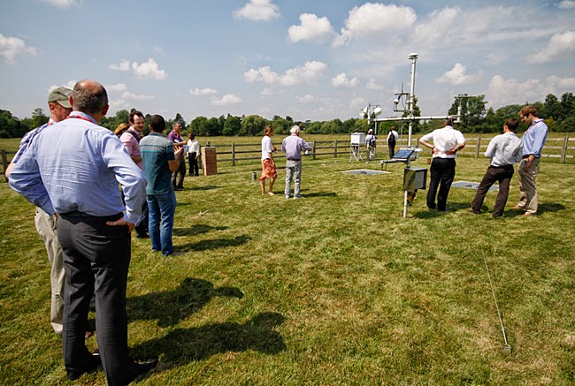
Members of the Royal Meteorological Society's Meteorological Observing Systems Special Interest Group have paid a visit to CEH to learn more about aspects of our monitoring work. The visitors were given a tour of our Meteorological Station at Wallingford (thankfully the weather was warm and sunny at the time!) and also heard more details about its history and observations from site manager Katie Muchan:


The visitors also heard a presentation from Dr Gareth Old about CEH's River Lambourn Observatory and research into chalk river systems:


Dr Jonathan Evans of CEH also presented on progress and early results from COSMOS-UK, the UK soil moisture monitoring network. The network will deliver real-time weather monitoring and field scale measurements of soil moisture across the United Kingdom.

Members of the RMetS Special Interest Group on Meteorological Observing Systems visit
CEH's Wallingford Meteorological Station, July 2014. Photo: Paul Fisher/ CEH


Further reading


Winter 2013/2014 rainfall records at CEH's Wallingford meteorological station 

A window on weather conditions at Wallingford

Sunday, 9 February 2014

Record breakers? Climate change, statistics and the recent UK floods

This morning the Met Office and the Centre for Ecology & Hydrology released a report on the recent storms and floods in the UK.

You can read the full report here, and a short summary of the hydrological analysis on our website here. 

The report documents the recent record-breaking weather and flooding episode, and discusses whether climate change contributed to the severity of the weather and its impacts. Climatology, meteorology and hydrology are covered in the report. 

In this blog post we highlight some of the hydrological conclusions that came from analysis of the long-term datasets held at CEH and our long history of research into floods.

With regard to the record-breaking nature of the flooding the report makes the following points:


  • The full gamut of flood manifestations – tidal, pluvial (flash), fluvial and groundwater – has been experienced over the last eight weeks.
  • The exceptional run of severe winter storms over December 2013 and January 2014 carried with them large amounts of rain which has led to very serious flooding across southern England. 
  • Estimated outflows (river flows) from Great Britain remained close to the highest ever recorded during late December and, subsequently, throughout most of January across large parts of England and Wales.
  • In a series from 1883, flows on the River Thames at Kingston (close to the tidal limit) remained above 275 m3 s-1 for longer than in any previous flood episode, and continue to exceed this threshold into early February. 
  • A preliminary analysis suggest that outflows aggregated over six weeks were the greatest since the 1947 floods – the most extensive in England & Wales during the 20th century.
  • In December and January, a few rivers (including the Mole, Wey and Medway, which, on the basis of preliminary data, recorded their highest flows since the extreme floods of September 1968) registered outstanding maximum flows. 
  • Generally, however, the peak flows registered during the recent flooding were not extreme. On the Thames the highest flow in 2014 has been exceeded during 14 earlier floods (most prior to 1950). 
  • The floodplain inundations across the UK caused major disruption to transport, agriculture and restricted sporting and recreational activities, and resulted in severe difficulties for some low-lying hamlets (most notably in the Somerset Levels). However, given the overall volume of runoff, the amount of property flooding at the national scale was relatively modest; a tribute to the general effectiveness of flood defences.


Figure 1: Combined flows (m3 s-1; black) for the Thames, Severn, Trent, Yorkshire Ouse and Usk in 2013 and January 2014, plotted against period of record (1969-2013) daily maximum flows (blue), daily minimum flows (pink) and daily mean flows (grey)

With regard to whether climate change has been a contributing factor to the current flooding the report states:


  • The cluster of drought and flood events through the early years of the 21st century and the recent runoff and recharge patterns, are near to the extreme range of historical variability, and therefore also raise the question that they may reflect anthropogenic climate change. It is important to note, however, that differing flood types may be expected to respond differently to increasing temperatures. Tidal flood risk is increasing as sea levels rise but the outlook is more complex in relation to fluvial flooding.
  • Published studies have observed increased river flows in the winter half-year and a tendency for higher flows to occur more frequently, and this has been reinforced in recent years. Importantly, however, such a trend may not be accompanied by any increase in magnitude of major flood events. In the UK, no positive trend in water-year maxima was found in the 130-year series for the Thames.
  • Enhanced groundwater flood risk may be expected if average winter rainfall in the UK increases. Flash flooding, which can be exacerbated by land management and land use practices (particularly the extension of impermeable areas), may also increase if the recent intensification in rainfall translates into an enduring trend. 
Much more detail can be found in the full report. More information about the report's conclusions is available on the Met Office website here.

Journalists can call our Press Office if more information is needed on the hydrological conclusions.

Barnaby Smith, CEH Media Relations Manager

Further links

Jamie Hannaford from the Centre for Ecology & Hydrology contributed a chapter to the Living with Environmental Change climate change report card for water entitled, "Observed long-term changes in UK river flow patterns: a review"


An interim update on the UK's hydrological situation - issued by CEH on 6 January 2014

Rainfall, UK floods and the potential impacts of climate change? - blog from 6 January 2014

NB: the Met Office updated the report on 11 February to give a more detailed assessment of sea level rise

Thursday, 10 October 2013

An unprecedented hydrological transformation

A huge number of scientific papers have delved into the extraordinary data held by the National River Flow Archive and National Groundwater Level Archive. As our blog series on hydrometric data continues, Simon Parry of CEH (right) discusses one of the most recent papers to use the data, newly published in the Weather journal, which analyses the dramatic transformation from drought to flood in the UK during the summer of 2012.

Whilst this year's fine and dry summer was very much welcome, it was not typical of the more unsettled summers of the last few years. Although the Olympic and Paralympic Games in 2012 were spared the worst of the weather, from April 2012 onwards a succession of wet fronts drenched the UK, in particular England & Wales, resulting in the wettest year for more than a century.

This episode emphatically put to an end concerns about the water resources situation, which saw hosepipe bans implemented in April across south, central and eastern England affecting 20 million consumers. Recent research by CEH scientists, in collaboration with the UK Met Office, published last month in Weather, finds that the transformation from drought to floods in England & Wales is without modern parallel in the historical record (Parry et al. 2013).

The extreme drought of 1975-76 remains the most severe in the historical record, most likely the worst experienced in the UK for at least the last 250 years (Rodda & Marsh 2011). This episode was terminated dramatically in September and October 1976, over which time England & Wales received almost double the long-term average rainfall.

The 2010-12 drought did not reach the same intensity as 1975-76 (Kendon et al. 2013); the summers were not hot or particularly dry in 2010-12, in contrast with heatwave-dominated droughts in 1976 and 2003. However, the rainfall shortages were concentrated in the winter half-years (October-March), a vital time for the recovery of water resources and, as such, outflows from England & Wales in March 2012 were lower than the corresponding point in 1976. Hosepipe bans were implemented in several areas at the end of the normal groundwater recharge season (April); there was little prospect of improvement in the water resources situation, barring something extraordinary happening...

Something extraordinary did happen. Whilst the transformation in 2012 may not have been as spectacular in rainfall terms as that of 1976, England & Wales recorded new record rainfall (series from 1766; Alexander & Jones 2001) for April, June and the summer half-year (April-September), and April-December 2012 was the wettest of any nine-month period in ~250 years.

Flood damage in England, December 2012. Photo: Heather Lowther


Groundwater recharge through the summer half-year

The most important impact of the succession of rain-bearing frontal systems was to re-wet soils which allowed the replenishment of groundwater to resume. What made the transformation in 2012 particularly unprecedented was the resumption of groundwater recharge through the summer half-year; the patterns of hydrological response tracked in the opposite direction to normal seasonal conditions.

Perhaps owing to the British preoccupation with the weather, much attention is given to rainfall figures in characterising the water situation in this country. However, water resources are more complex than this; the relationship between rainfall and runoff is not one-to-one, owing to catchment characteristics and antecedent conditions.

The distinction between a transformation in rainfall and the unprecedented hydrological transformation is an important one; the former would not necessarily have terminated hydrological drought conditions, but the latter did so emphatically. If there had been no concurrent response in groundwater levels following the rainfall, it is likely that hosepipe bans would have remained in place even through a moderately wet summer. This would have been a difficult message for the water companies to communicate to the public, so perhaps the industry was happy on more than one level to have witnessed a hydrological transformation without modern parallel.

Simon Parry

Simon Parry is a hydrologist based at the Centre for Ecology & Hydrology's Wallingford site.


References


Alexander, L V, and Jones, P D (2001) Updated precipitation series for the UK and discussion of recent extremes. Atmospheric Science Letters, 1, 142-150.

Kendon, M, Marsh, T and Parry, S (2013) The 2010-2012 drought in England and Wales. Weather, 68 (4), 88-95.

Parry, S, Marsh, T and Kendon, M (2013) 2012: from drought to floods in England and Wales. Weather, 68 (10), 268-274.

Rodda, J C and Marsh, T J (2011) The 1975-76 drought - a contemporary and retrospective review, Centre for Ecology & Hydrology. 58pp. [PDF, 13mb]

Additional information


A comprehensive report by Terry Marsh, Simon Parry and Jamie Hannaford, in collaboration with Mike Kendon (Met Office), on the 2010-12 drought and subsequent hydrological transformation will be published later this month and will be available to download freely from the CEH website.

Next in our hydrometric data blog series, Looking forward - where the archives are going next... Watch this space!

Related links

CEH Blog: Hydrometric data - the long view

National River Flow Archive  

Thursday, 14 March 2013

A window on weather conditions at Wallingford

A 50th anniversary at CEH has passed almost unnoticed. The meteorological station at our Wallingford, Oxfordshire site has now been measuring daily rainfall, sunshine and temperature parameters since 1962 (when the Hydrological Research Unit, which later became the Institute of Hydrology, was established here).

The station is used to monitor local weather conditions on a daily basis and data is submitted regularly to the Met Office. As well as forming part of the UK Climatological Observation Network, records from the site are used to support instrumentation calibration and other scientific projects. Such long-term observations help develop an understanding of hydrometeorological systems and may also show trends over time which could be linked to environmental change.

Near real-time data from the met station from the last six months is now available to view on our website, while full historic data can also be requested. You can also learn more about the type of manual observations which are recorded at the site, and a little bit more about how far back some of the records go, in an information leaflet entitled "Why measure meteorological variables?" [PDF].

A ground level rain gauge in the foreground and a
Stevenson screen in the background at CEH's met station
in Wallingford, Oxfordshire.
Photo: Harry Dixon/Centre for Ecology & Hydrology


References


Rainfall measurement revisited - a paper in Weather by John Rodda and Harry Dixon revisiting work done at Wallingford in the 1960s looking at raingauge design

Weather Monitoring - a paper published in June 2011 in AWE International by Mark Robinson and Geoff Wicks  

CEH's Wallingford Meteorological Station