Several CEH scientists are in Birmingham this week at the 12th British Hydrological Society National Symposium. This year’s theme is “Challenging hydrological theory and practice.”
The symposium, which takes place from 2-4 September 2014, is one of the main meetings for the UK’s hydrological community, a community in which CEH plays a key role, through both our research on issues such as water resources, floods and droughts, and our extensive hydrological data management remit.
CEH has a stand at the conference. Visitors are being shown this video highlighting the wide range of hydrological research we carry out:
Ten CEH staff are speaking at the conference on a wide range of subjects. Their presentations are as follows:
1. Natural or designer environmental flows for a changing world? Prof Mike Acreman
2. Predicting physical habitat sensitivity to abstraction. Cedric Laizé
3. Overdispersion in peak over threshold (POT) flow data and its effect on flood frequency practice.
Dr Ilaria Prosdocimi
4. The new FEH rainfall depth-duration-frequency model: results,
comparisons and implications. Lisa Stewart
5. What do we talk about when we talk about drought? Jamie Hannaford
6. Real-time modelling of surface water flooding hazard and impact at
countrywide scales. Dr Steven Cole
7. Presentation of the new CEH-GEAR dataset: fine resolution daily and monthly
areal rainfall estimates for the UK for hydrological use Dr Maliko Tanguy
8. Can land use and land management make a difference to water
availability? Helen Houghton-Carr
9. How do we want to access hydrological data over the web? Matt Fry
10. Ensuring UK hydrometric data is fit-for-purpose through a national
Service Level Agreement. Katie Muchan
Conference attendees are tweeting using the hashtag #BHS2014
Links
Conference website
Conference programme

Showing posts with label hydrometry. Show all posts
Showing posts with label hydrometry. Show all posts
Wednesday, 3 September 2014

Sunday, 9 February 2014
Record breakers? Climate change, statistics and the recent UK floods
 This morning the Met Office and the Centre for Ecology & Hydrology released a report on the recent storms and floods in the UK.
You can read the full report here, and a short summary of the hydrological analysis on our website here.
The report documents the recent record-breaking weather and flooding episode, and discusses whether climate change contributed to the severity of the weather and its impacts. Climatology, meteorology and hydrology are covered in the report.
In this blog post we highlight some of the hydrological conclusions that came from analysis of the long-term datasets held at CEH and our long history of research into floods.
With regard to the record-breaking nature of the flooding the report makes the following points:
- The full gamut of flood manifestations – tidal, pluvial (flash), fluvial and groundwater – has been experienced over the last eight weeks.
- The exceptional run of severe winter storms over December 2013 and January 2014 carried with them large amounts of rain which has led to very serious flooding across southern England.
- Estimated outflows (river flows) from Great Britain remained close to the highest ever recorded during late December and, subsequently, throughout most of January across large parts of England and Wales.
- In a series from 1883, flows on the River Thames at Kingston (close to the tidal limit) remained above 275 m3 s-1 for longer than in any previous flood episode, and continue to exceed this threshold into early February.
- A preliminary analysis suggest that outflows aggregated over six weeks were the greatest since the 1947 floods – the most extensive in England & Wales during the 20th century.
- In December and January, a few rivers (including the Mole, Wey and Medway, which, on the basis of preliminary data, recorded their highest flows since the extreme floods of September 1968) registered outstanding maximum flows.
- Generally, however, the peak flows registered during the recent flooding were not extreme. On the Thames the highest flow in 2014 has been exceeded during 14 earlier floods (most prior to 1950).
- The floodplain inundations across the UK caused major disruption to transport, agriculture and restricted sporting and recreational activities, and resulted in severe difficulties for some low-lying hamlets (most notably in the Somerset Levels). However, given the overall volume of runoff, the amount of property flooding at the national scale was relatively modest; a tribute to the general effectiveness of flood defences.
 |
Figure 1: Combined flows (m3 s-1; black) for the Thames, Severn, Trent, Yorkshire Ouse and Usk in 2013 and January 2014, plotted against period of record (1969-2013) daily maximum flows (blue), daily minimum flows (pink) and daily mean flows (grey)
- The cluster of drought and flood events through the early years of the 21st century and the recent runoff and recharge patterns, are near to the extreme range of historical variability, and therefore also raise the question that they may reflect anthropogenic climate change. It is important to note, however, that differing flood types may be expected to respond differently to increasing temperatures. Tidal flood risk is increasing as sea levels rise but the outlook is more complex in relation to fluvial flooding.
- Published studies have observed increased river flows in the winter half-year and a tendency for higher flows to occur more frequently, and this has been reinforced in recent years. Importantly, however, such a trend may not be accompanied by any increase in magnitude of major flood events. In the UK, no positive trend in water-year maxima was found in the 130-year series for the Thames.
- Enhanced groundwater flood risk may be expected if average winter rainfall in the UK increases. Flash flooding, which can be exacerbated by land management and land use practices (particularly the extension of impermeable areas), may also increase if the recent intensification in rainfall translates into an enduring trend.
Journalists can call our Press Office if more information is needed on the hydrological conclusions.
Barnaby Smith, CEH Media Relations Manager
Further links
Jamie Hannaford from the Centre for Ecology & Hydrology contributed a chapter to the Living with Environmental Change climate change report card for water entitled, "Observed long-term changes in UK river flow patterns: a review"
An interim update on the UK's hydrological situation - issued by CEH on 6 January 2014
Rainfall, UK floods and the potential impacts of climate change? - blog from 6 January 2014
NB: the Met Office updated the report on 11 February to give a more detailed assessment of sea level rise
NB: the Met Office updated the report on 11 February to give a more detailed assessment of sea level rise
Thursday, 3 October 2013
Hydrometric data: The Long View
Each week BBC Radio 4's The Long View uses a variety of expert witnesses to examine stories from history that resonate in today's headlines.
Later this month, CEH will host more than 100 distinguished hydrologists who will spend a day taking the 'long view' of the data collection and research work of the UK's National River Flow Archive (NRFA) and National Groundwater Level Archive (NGLA), both of which have been hosted at our Wallingford site since the early 1980s, but which contain records dating back to the first half of the 19th century.
The 30th anniversary celebration of the Wallingford move, to be held on 22 October 2013, will review the achievements of the archives and the exploitation of this rich hydrological data resource by a broad user community, which includes regulators such as the Environment Agency, water companies, academic scientists, and environmental and engineering consultancies. The data has also made its way into several scientific papers referred to in the recent IPCC WG1 assessment.
In addition to river flow and groundwater level data, rainfall records and reservoir levels are also held in the archives and the incredible dataset has allowed CEH and BGS scientists to produce a variety of key publications examining both hydrological trends – for example, Are UK floods getting larger? – and the significance of one-off events, such as the 1976 drought. Comparisons between the latest data and the historic record also provide the backbone of the UK's monthly hydrological summary.
Whilst delving through the archives in preparation for this post, I came across this fascinating history of hydrological monitoring before 1985 [PDF], which details how, although Britain has a three centuries-long history of rainfall recording, river flow monitoring only became 'fashionable' after the second world war as industry and government increased their demand for water. The work to establish a national river flow gauging network in the 1950s and 1960s built on a small number of sites that had been established over the previous century, including Wendover Springs in Buckinghamshire - thought to be the earliest extant stream flow monitoring site in the UK.
On the day itself, presenters will look back at how hydrometric monitoring developed in the UK, in response to factors such as the perceived increase in water requirements. They will also examine some of the latest techniques for both monitoring the UK's water cycle, investigate how monitoring and the archive might develop in the future, and tackle the difficult question of what data should we be archiving nationally, given the resource constraints imposed by the current financial situation. In summary, they will take a 'Long View' of a data archive from one of the UK's major environmental monitoring networks, an archive which is particularly important because the UK climate is inherently variable, so short-term tendencies may well not be indicative of long-term trends.
Barnaby Smith
CEH website: Images of gauging stations which have provided some of the oldest records in the archive
Flickr: Album of historic images from the Pynlimon catchments
Over the next couple of weeks we will be blogging in more detail about some of the material being presented at the meeting. Further details of the meeting can be found here. Registration is now closed but we will be making much of the content available from this blog and the NRFA pages on the CEH website.
If you're interested in learning more, take a look at the NRFA web pages, where you can find reams of information on how monitoring takes place and how the data is used, and you can also download data for more than 400 of the UK's river flow gauging sites. Information about the records and details of scientific papers which have used the records can be found on the NRFA publications pages.
Later this month, CEH will host more than 100 distinguished hydrologists who will spend a day taking the 'long view' of the data collection and research work of the UK's National River Flow Archive (NRFA) and National Groundwater Level Archive (NGLA), both of which have been hosted at our Wallingford site since the early 1980s, but which contain records dating back to the first half of the 19th century.
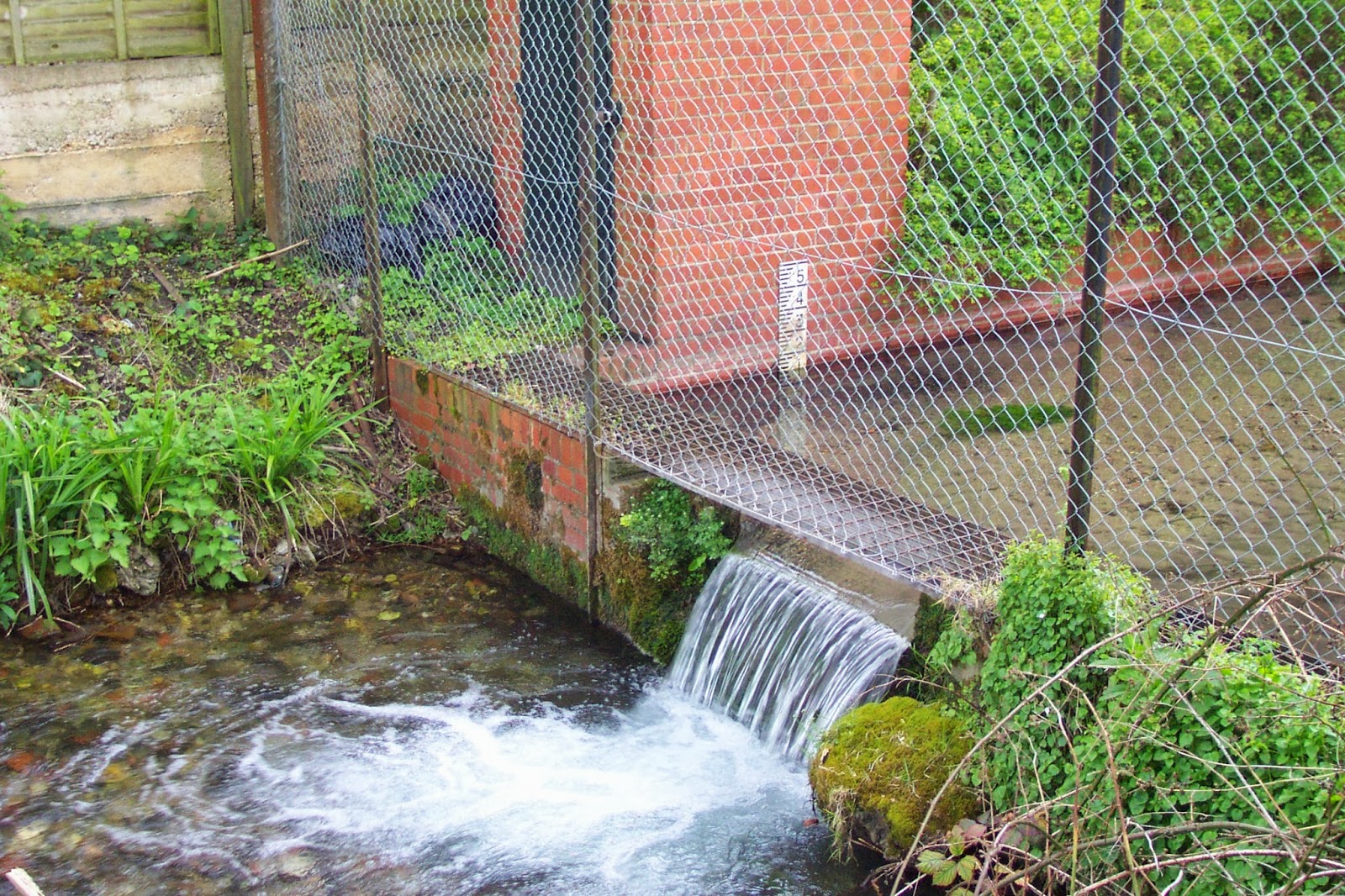 |
| Wendover Springs - thought to be the earliest extant stream flow monitoring site in the UK. |
In addition to river flow and groundwater level data, rainfall records and reservoir levels are also held in the archives and the incredible dataset has allowed CEH and BGS scientists to produce a variety of key publications examining both hydrological trends – for example, Are UK floods getting larger? – and the significance of one-off events, such as the 1976 drought. Comparisons between the latest data and the historic record also provide the backbone of the UK's monthly hydrological summary.
Whilst delving through the archives in preparation for this post, I came across this fascinating history of hydrological monitoring before 1985 [PDF], which details how, although Britain has a three centuries-long history of rainfall recording, river flow monitoring only became 'fashionable' after the second world war as industry and government increased their demand for water. The work to establish a national river flow gauging network in the 1950s and 1960s built on a small number of sites that had been established over the previous century, including Wendover Springs in Buckinghamshire - thought to be the earliest extant stream flow monitoring site in the UK.
On the day itself, presenters will look back at how hydrometric monitoring developed in the UK, in response to factors such as the perceived increase in water requirements. They will also examine some of the latest techniques for both monitoring the UK's water cycle, investigate how monitoring and the archive might develop in the future, and tackle the difficult question of what data should we be archiving nationally, given the resource constraints imposed by the current financial situation. In summary, they will take a 'Long View' of a data archive from one of the UK's major environmental monitoring networks, an archive which is particularly important because the UK climate is inherently variable, so short-term tendencies may well not be indicative of long-term trends.
Barnaby Smith
CEH website: Images of gauging stations which have provided some of the oldest records in the archive
Flickr: Album of historic images from the Pynlimon catchments
Additional information
Over the next couple of weeks we will be blogging in more detail about some of the material being presented at the meeting. Further details of the meeting can be found here. Registration is now closed but we will be making much of the content available from this blog and the NRFA pages on the CEH website.
If you're interested in learning more, take a look at the NRFA web pages, where you can find reams of information on how monitoring takes place and how the data is used, and you can also download data for more than 400 of the UK's river flow gauging sites. Information about the records and details of scientific papers which have used the records can be found on the NRFA publications pages.
Subscribe to:
Posts (Atom)